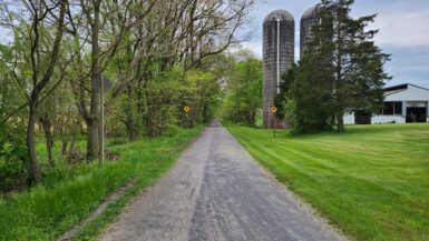
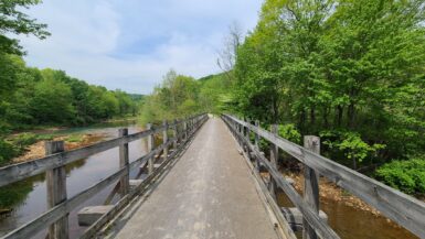
The West Penn Trail is what you get when you cross a well-maintained, paved, road-bike friendly trail with a well-maintained, single-track, goat-friendly mountain bike trail. The trail is located in western PA and runs between the towns of Saltsburg and Blairsville. It’s got three distinct personalities and as such will give both intermediate and beginner (with one important note; see below) riders a fun ride.
Western Pennsylvania is becoming a major player in celebrating their industrial heritage through rail trails. Future plans call for expansion of the trail east to pick up the Hoodlebug and Ghost Town Trails, and north towards Apollo. And at the trail’s terminus in Saltsburg, you can easily pick up the Westmoreland Heritage Trail.
History
The story of the West Penn Rail Trail dates back nearly 200 years to the Main Line of Public Works — a series of canals and roads designed to transport freight through Pennsylvania. The mountainous terrain made this an extremely difficult proposition. Tunnels, aqueducts, and locks helped canal boats navigate the terrain, and remnants of this period are clearly visible along the Conemaugh Dam section of the trail.

The original canal gave way to railroads beginning in the 1850s. After multiple bankruptcies, acquisitions, and realignments (many of which are visible on state LIDAR imaging), the North Western Railroad — later reorganized as the West Penn Railroad ultimately became part of the Pennsylvania Railroad. Parts of the original rail line are still in use, which necessitates some scenic, off-road detours along the way.
Getting There
There are three main ways to access the trail:
The Saltsburg trailhead offers ample parking and a handful of restaurants for those after-ride celebrations. From here you can also pick up the Westmoreland Heritage Trail. This allows you to tackle both in a single ride with a refueling stop at your car. Just know that not all of the restaurants are open every day, so check hours before you go.
The Conemaugh Dam trailhead also offers ample parking, plus public restrooms and a picnic pavilion. It’s roughly halfway along the trail, and serves as the last eastbound stop before the more challenging Bow Ridge section.

The Blairsville trailhead is just northwest of Blairsville and serves as the eastern terminus. There are no facilities here, but this sets you up for a very leisurely four-mile ride to Bow Ridge. Getting here requires you to traverse a short access road just off Newport Road. Some people think this access road is part of the trail; it is not. Keep driving about a quarter mile until you encounter a large gravel parking lot and trail signage.
Normally I prefer to start in Saltsburg. I keep telling myself I’m going to double this up with the Westmoreland Heritage Trail … so far, no luck. If you start on the Blairsville side, I highly recommend breakfast at Dean’s Diner. It’s an old-school diner that serves massive pancakes and industrial-strength coffee for dirt cheap. It’s barely a five-minute drive from the Blairsville trailhead.
The Trail

The West Penn Trail is a well-maintained trail that’s in generally good condition. Except for a brief half mile between Auen Road and the Conemaugh Dam, the trail is always well-marked and easy to follow. Trail surface is mostly packed dirt, with some extremely rough concrete sections along the bridges east of Bow Ridge. Leave the road bike at home and bring something a little more rugged, like a gravel or hybrid.
There are four main sections to the trail. At either end, the trail offers several miles of shady, flat trail that’s suitable for all skill levels. West of Conemaugh Dam is about 3.5 miles of hilly, moderately rough trail. This is where the trail diverts through state game lands #328. This section features a few short inclines and narrower trail. Finally, the trail follows a mile-long series of switchbacks over Bow Ridge. The trail is in good condition here, but this is a significant hike — especially on the eastern side.
The trail is steeped in history, and placards along the route will turn you into a West Penn Historian in no time. The most interesting section is, without any doubt, Bow Ridge.
Sections 1 & 4: The Easy Part

Whether you start from Blairsville or Saltsburg, the first few miles of the West Penn offer a shady, flat trail that’s suitable for all skill levels. Here the trail is well-marked, heavily shaded, and visually easy to follow. If you’re looking for an introductory rail trail ride to share with young children, it’s hard to beat this stretch.
The Saltsburg side is almost entirely shaded, but the Blairsville side passes over several very old railroad bridges. It’s hard to decide which is better.

As you approach Bow Ridge from the east, you’ll begin to see signs of how the trail was realigned over the years. Apart from the visible grade changes from abandoned routes, you can also see many examples of abandoned bridgework and abutments along the way.
Section 2: Dick Mayer

About 4.5 miles east of Saltsburg, the trail branches off from the main rail line and cuts through state game lands (friendly reminder: wear high-visibility colors like neon yellow or safety orange). Here the trail gets a little rougher, and you’re going to want a gravel or hybrid. Trail grade hovers around 3% – 5% for most of this section. Not a show stopper, but enough to give you a workout.

This section cuts deep through the forest, so naturally you’re going to get some of the most beautiful scenery along the trail. Pay close attention as you cross Auen Road: the trail from here to Conemaugh Dam is not well marked. During the fall, the path can be buried under leaves and difficult to follow.
Section 3: Conemaugh Dam / Bow Ridge
Bow Ridge is by far the steepest and most difficult part of the trail. The west side is fairly forgiving with a climb of only 4% – 5.5%, but the eastern face is so steep that it comes with a set of stairs to walk your bike. Signs warn you about the grade. Listen to them! I thought “you’re not the boss of me” and almost ended up head over handlebars.
Bow Ridge is home to four tunnels. The “newest” tunnel was built in 1907 and bypassed around 1950. Because the then-new Conemaugh Dam raised the water level on the other side, this tunnel was sealed with a two-foot-thick concrete plug to prevent it from emptying the reservoir during floods. This tunnel is easily visible from both the western and eastern sides of Bow Ridge. On the eastern side, this is the tunnel that aligns with the rest of the trail. The keystone reads “A.C. SHAND, Chief Engineer. McMENAMIN & SIMS, Contractors. 1907”.
The older Bow Tunnel was built in 1864. Like the 1907 tunnel, this tunnel is plugged to prevent the reservoir from draining. Piers from the bridge that accompanied this tunnel are still easily visible in the Conemaugh River. This tunnel is also visible from the eastern side of Bow Ridge, but is in a severe state of collapse and slightly harder to find.
Between the two tunnels and buried under the mountain rests an even older tunnel. In 1827, a canal tunnel fed into an aqueduct to the west, allowing canal boats to safely pass around the ridge and continue on the canal. Geology of the region meant that digging an adjacent canal would have been a staggering engineering feat; blasting through the mountain was easy in comparison. Today this tunnel rests far below the water line on the east side, but a small drainage pipe is barely visible on the west.
A fourth tunnel was bored in 1989 to feed a nearby hydro power generator. This tunnel isn’t accessible for obvious reasons, but the extremely dangerous intake and blowback is visible from the eastern side.
Conclusion
The West Penn Trail is a mix of beginner and intermediate riding. The heavy shade makes it an enjoyable and easy summer ride, even if you skip the Dick Mayer and Bow Ridge sections. I wish Saltsburg had more restaurants open when I visited, but that’s life in a small town.
Official website: https://conemaughvalleyconservancy.com/initiatives/west-penn-trail/
Traillink profile: https://www.traillink.com/trail/west-penn-trail/


Leave a Reply